Bhunaksha Odisha is a cadastral mapping software developed by NIC using Open source applications and libraries to facilitate the management of digitized cadastral maps. With proper customization, Bhunaksha can be integrated with the existing Land Records application of any state that deals with textual data.
How to check the Bhu-Naksha Online Land Maps Portal of Odisha?
Steps:- 01
Enter Your Preferred District Name

Steps:- 02
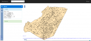
After Select District. Then input your information as per your desired address by selecting Tahasil, RI, Village, and sheet number. Then you can see your BhuNaksha as per your requirement and you can zoom in and zoom out the BhuNaksha.
Here We have added a step-by-step video on how to check BhuNaksha Odisha. Go through the video it will be easier and more helpful for you to get information.